


FINDING YOUR WAY IN LES 2 ALPES
Les 2 Alpes ski map:
piste, bike and hiking maps
Skiing in winter, the Bike Park and walking routes in summer: find the maps you need to plan your day and download the version that suits your activity.
View and download piste and bike maps by sector.
⛷️ Skiing & snowboarding
Spot the pistes, lifts and main links across the ski area.
🥾 Hiking & walks
Plan your routes and discover the areas you can reach on foot.
🚵 Mountain biking & Bike Park
See the trails, the levels and the different access points across the area.
⛷️ Skiing & snowboarding
🚵 Mountain biking & Bike Park
🥾 Hiking & walks
- Home |
- Plan des Pistes Les 2 Alpes
AN EXCEPTIONAL AREA
⛷️ Skiing & snowboarding
Spot the pistes, lifts and main links across the ski area.
🥾 Hiking & walks
Plan your routes and discover the areas you can reach on foot.
🚵 Mountain biking & Bike Park
See the trails, the levels and the different access points across the area.
Les 2 Alpes, 360° of fun in every season
From the glacier at 3,600 m down to the resort at 1,650 m, enjoy a ski area unlike any other in Europe. Skiing in winter, mountain biking in summer: experience the mountains differently, on a grand scale.
1,650 – 3,600 m
from the resort to the high-altitude ski area
220 km
of pistes in the ski area
91 km
of mountain bike trails
Summer & winter
Exceptional panoramic views
1,650 – 3,600 m
from the resort to the high-altitude ski area
220 km
of pistes in the ski area
91 km
of mountain bike trails
Summer & winter
Exceptional panoramic views
01
Winter
The ski area at a glance
Between the resort, the mid-mountain sectors and the high-altitude area, Les 2 Alpes spreads over several levels. The right map lets you see the pistes, lifts, links and areas suited to how you ski before you set off.
88 pistes
16 green · 46 blue · 16 red · 10 black
7 sectors
from the bottom of the pistes to the glacier
44 lifts
Drag lifts, magic carpets, gondolas, telemix lifts…
3,600 m
Glacier altitude, for skiing from late November to early July
88 pistes
16 green · 46 blue · 16 red · 10 black
7 sectors
from the bottom of the pistes to the glacier
44 lifts
Drag lifts, magic carpets, gondolas, telemix lifts…
3,600 m
Glacier altitude, for skiing from late November to early July
02
Maps to download
Ski maps 2026
Download the general map or open the map of the sector you are interested in. The detailed sectors are mainly useful for preparing a targeted day, finding a beginner area or understanding the links across the ski area.
General ski area map
The whole resort: the reference map for seeing all the pistes, lifts and sectors.
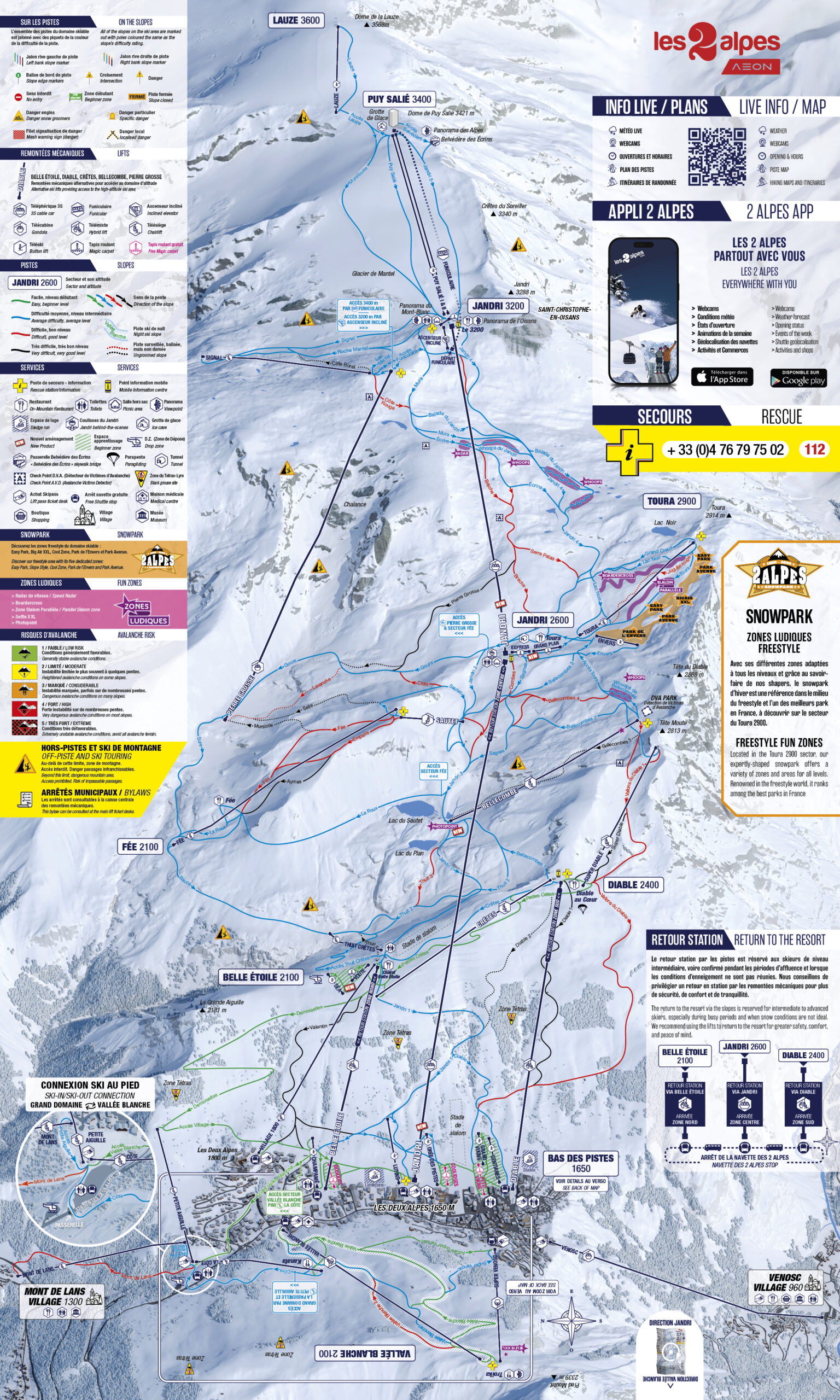
High-altitude area
3,200–3,600 m: the highest sector of the ski area and its panoramic access points.
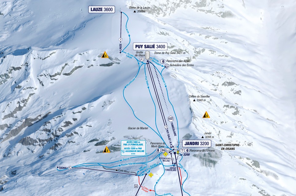
Toura / Snowpark
2,600–2,900 m: freestyle, pistes in the heart of the ski area and the Snowpark.
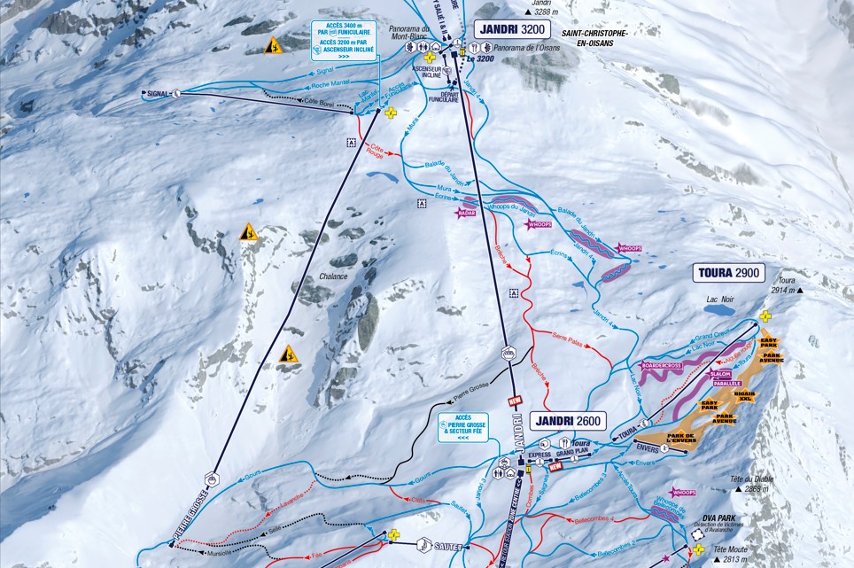
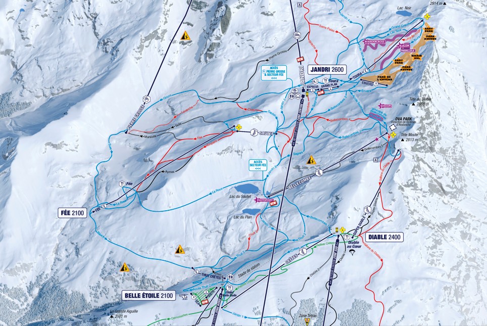
La Fée
≈ 2,100–2,200 m: a wilder sector and an important link up to altitude.
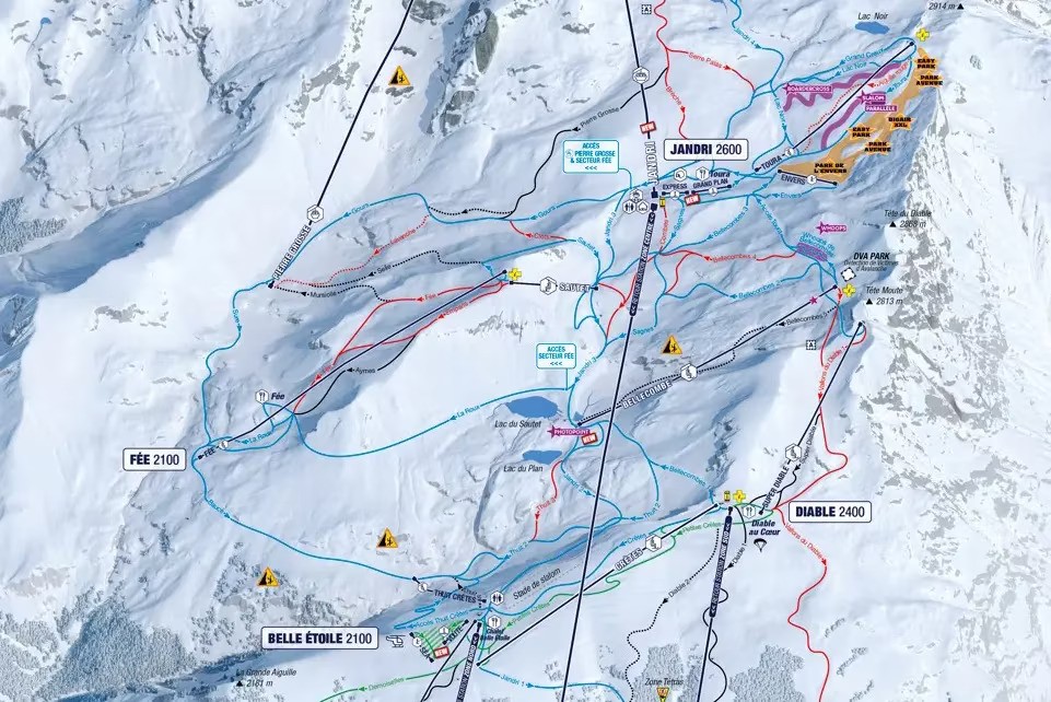
Le Diable
2,400 m: more demanding pistes and long descents.
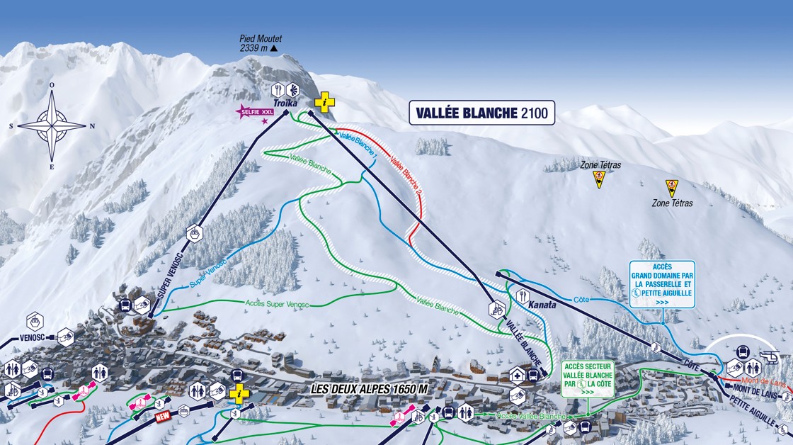
Vallée Blanche
2,100 m: a panoramic slope, calmer and easy to reach.
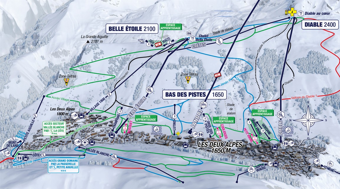
Belle Étoile
2,100 m: an easy-to-reach sector, suited to beginners and intermediates.
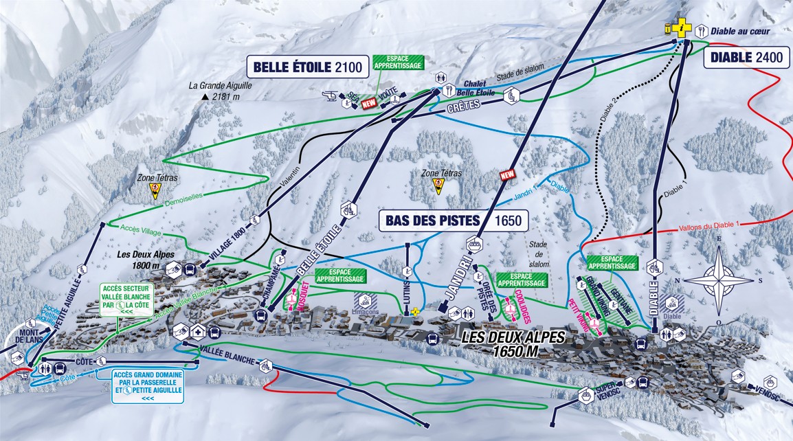
Bottom of the pistes
1,650 m: snow front, ski schools and beginner areas.
03
Maps to download
Mountain bike, Bike Park and hiking maps 2026
In summer, the bike maps are the main way to understand the sectors, levels and lifts open to bikes. Download them here before you set off.
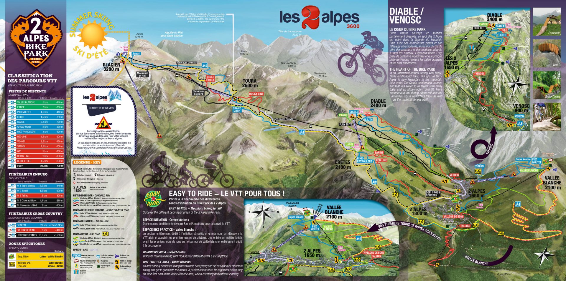
General Bike Park map
All sectors: the main map of the 2 Alpes Bike Park™ and its routes.
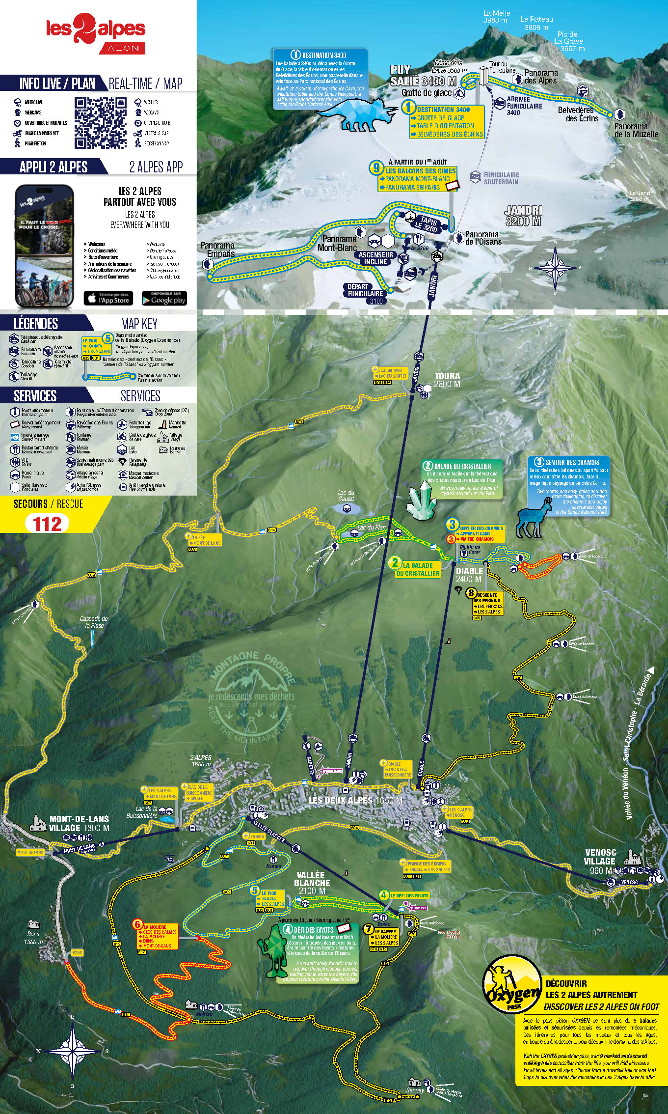
Walking map 2026
To find the paths and links across the ski area.
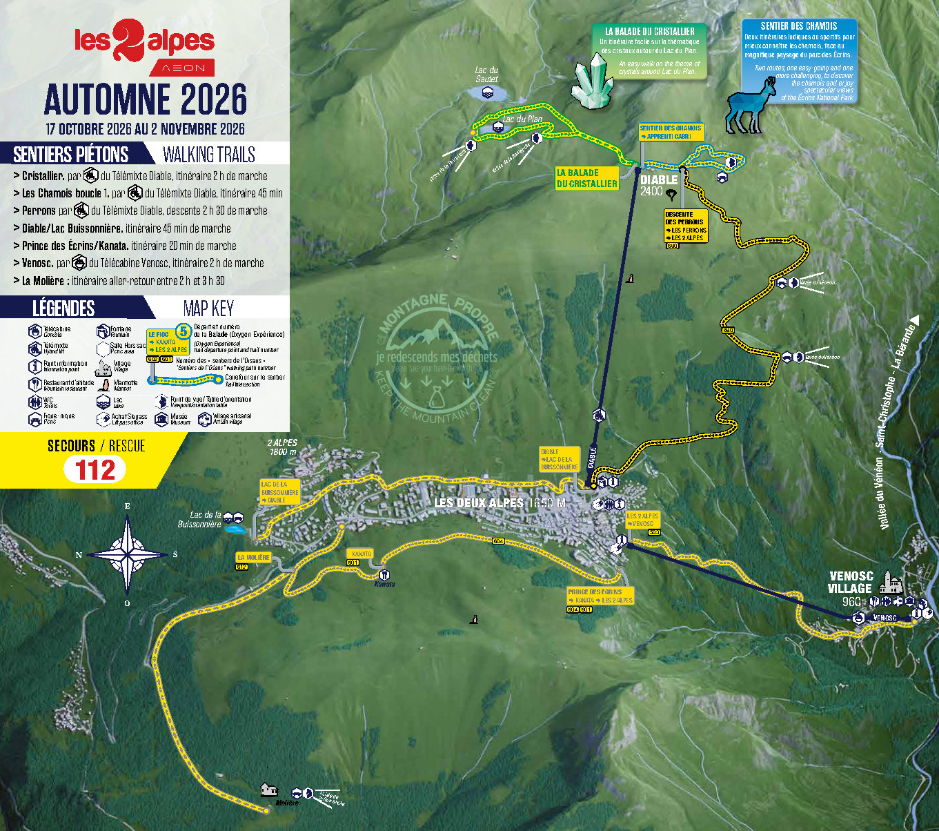
Walking, All Saints’ 2026
Walks for the All Saints’ holiday 2026
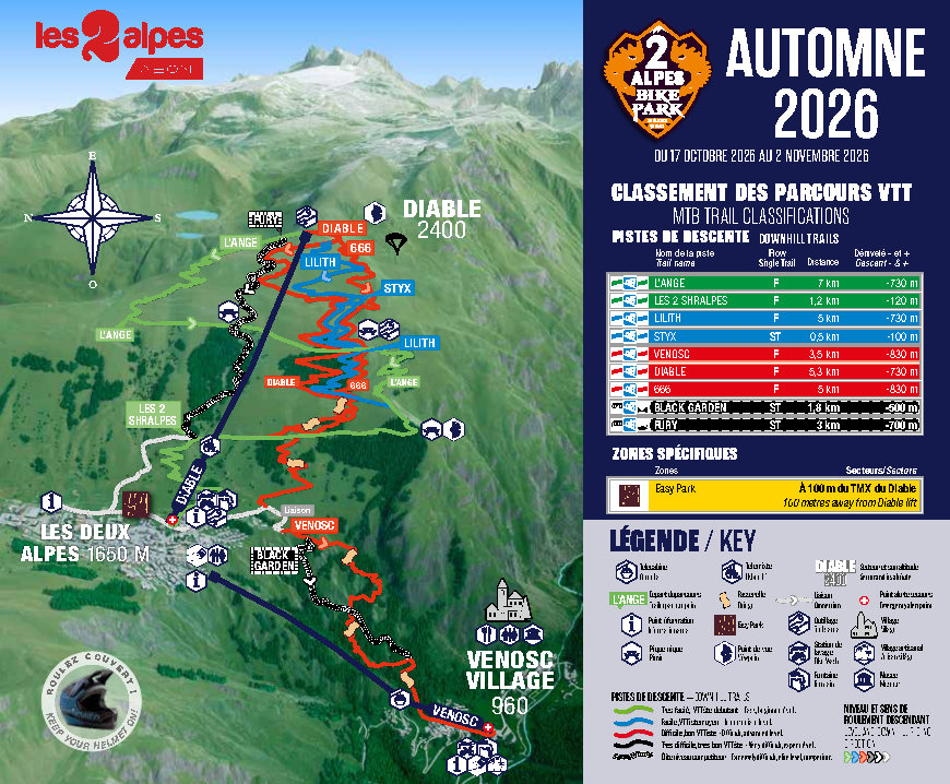
Opening, All Saints’ 2026
Mountain biking & hiking
04
Mountain bike and hiking area
Walking maps & summer discovery
The lifts also give access to several walking routes and viewpoints. A dedicated map helps you choose a walk, an access point at altitude or a link between sectors.
FAMILY
OVERVIEW
Ski / mountain bike / walking map of the high-altitude area
A combined map, useful when several activities share the same area.
THE RESORT IN DETAIL
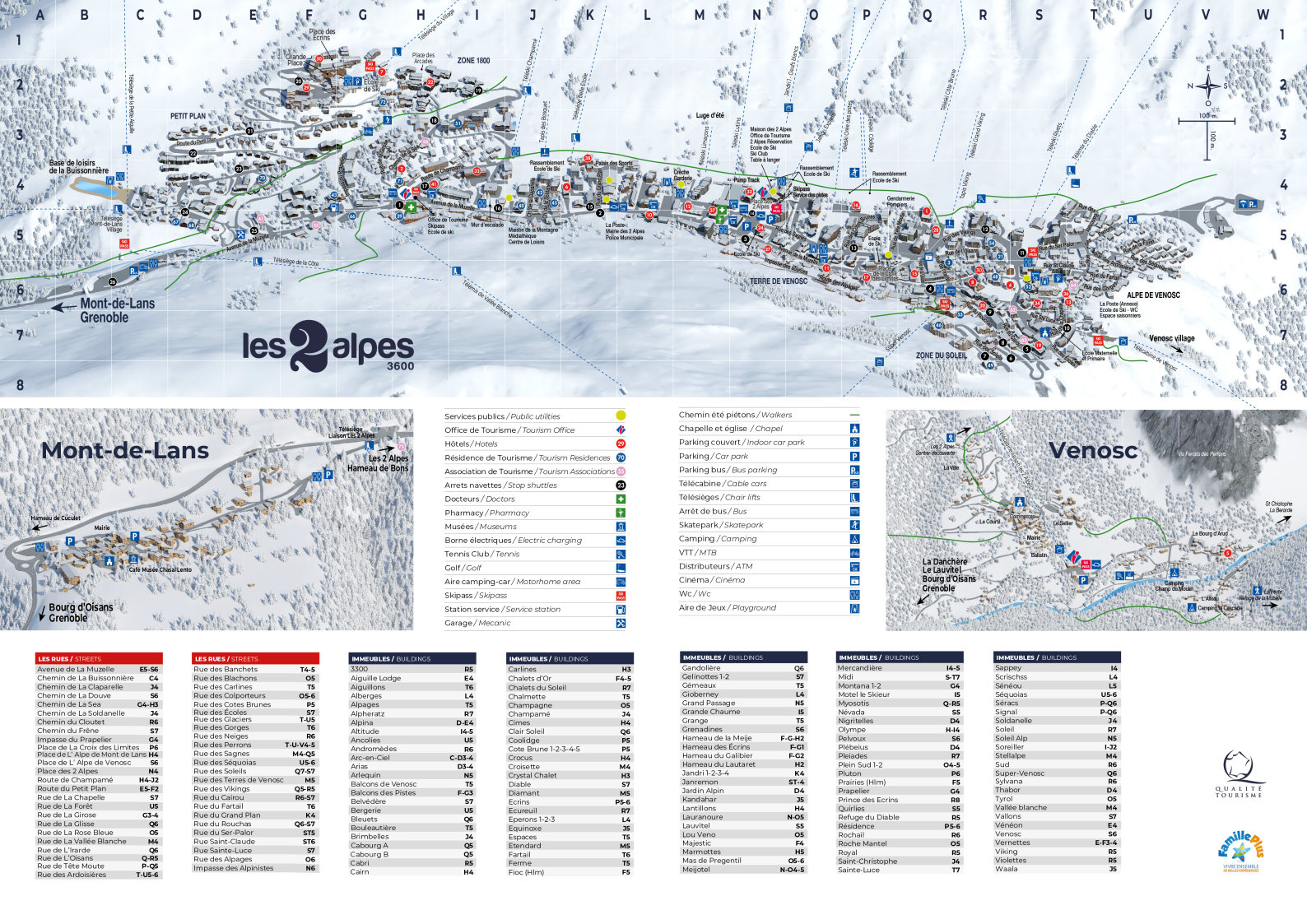
Resort map
To complete your preparation: streets, accommodation, services and access to the lifts.
05
Before you go
Which map should you choose?
Each map meets a different need. Start with your activity, then the level of detail you need: an overview to understand the area, or a sector map to plan your route precisely.
Choose your activity, then open the general map or the detailed map of the sector you are interested in.
01
I’m coming to ski
Start with the general ski area map, then open a sector to see the pistes and links in detail.
02
I’m coming to mountain bike
Download the general Bike Park map, then use the sector maps to plan your descents.
03
I’m coming to hike
Check the summer maps to find walking routes, open lifts and high-altitude sectors.
04
I’m looking for somewhere in the resort
Use the resort map to locate the neighbourhoods, lift departures and main services.
06
PLAN YOUR OUTING
One ski area, a thousand experiences
From the ski area to the summer routes, the maps let you see distances, links and differences in altitude. A few minutes of preparation is all it takes to choose a suitable route and enjoy the mountains more calmly.
Winter or summer, a few minutes are enough to choose a suitable route and plan your day better.
- Find the pistes and routes that suit your level.
- Check the links and lifts you need for your route.
- Download your map before you set off so you can keep it with you.
07
Your questions, our answers
5 questions about your maps
Map updates, downloading to your phone, bike maps or walking routes: find answers to the most common questions before planning your route in Les 2 Alpes.
Updates, downloads and summer and winter maps: the essentials for using the Les 2 Alpes maps easily.
Yes. Maps and opening dates change; always use the version showing the current year or period.
Yes. You can save the PDFs before your day out so they stay available even with a limited connection.
No. A map shows the ski area; to know which pistes and lifts are open, check the official information for the day.
Yes. The Bike Park has dedicated maps of the trails and bike sectors.
Yes. Walking maps show the routes you can reach with or without the lifts, depending on the season.
GET ORGANISED
Is your map ready?
Now check the weather and webcams before you head out onto the ski area.